Tuesday, August 14, 2012

I Can Hear a Bullfrog Calling Me....Jessup Path Acadia

Bar Harbor, ME   High: 73  Low:  65

It was a drizzly foggy day, but we wanted to get out and get some exercise...The Jessup Path to Great Meadow Loop is a wonderful, easy hike, a "lollipop" type of trail...If you did the entire loop, it would be a 3.1 mile hike through woods, wetlands, and fields. The wetlands have a nice long boardwalk for that part of the walk, and part of the trail is gravel, making part of the hike wheelchair accessible.

Because we didn't have our maps with us today, we just weren't really sure where to hook up with the Great Meadow Trail to complete the loop. So we started at the Sieur de Mont trailhead, made a right, and first walked through a heavy, lush forest of grasses and birches. The boardwalk IS the Jessup Path and after it ends, it  runs into another trail that intersects it, Hemlock Road, then turns into a gravel based trail continuing to the Great Meadow Loop.
We continued on to where the trail ends briefly at the Park Loop Road. We didn't know that to continue the loop, you have to cross the Park Loop Road and pick up the Great Meadow Trail to continue on clockwise. Had we continued on the Great Meadow Loop, we would have seen the Kebo Valley Golf course, two cemeteries near brooks, and the outskirts of Bar Harbor.  The clouds of fog were rolling in, the mist was getting heavier.

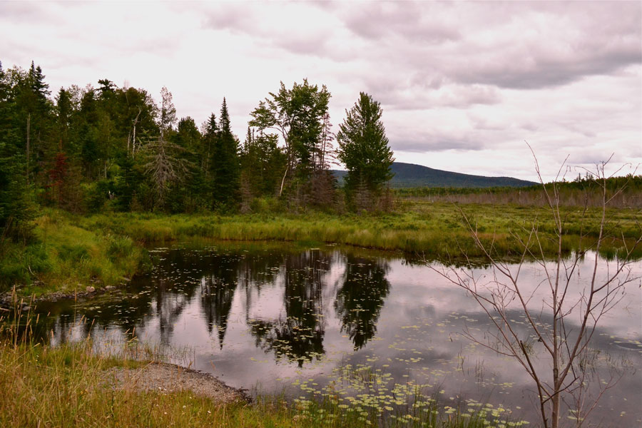
We decided to turn back at the Park Loop Road junction. If you take this hike, you can see Champlain Mountain to the left, and Dorr Mountain to the right at this point. We traveled back to the Sieur de Mont parking lot, for a total distance of about a mile and a quarter. On the way back, Sparky stopped to take photos of a "bullfrog calling me" (some song has that refrain in it, doesn't it?) in the marsh.

This path has some historical background as George Dorr, the "father of Acadia", first created this path over 100 years ago as part of a garden path that connected to downtown Bar Harbor. This trail has been recently re-created as part of the Friends of Acadia and National Park Forest Service efforts to give residents and visitors the opportunity to walk between the towns, mountains, ponds and seas, just as they did hundreds of years ago. People didn't think anything of a walk that would be five to twenty miles a day back then. Sparky and Eldo have a LO-O-O-N-G way to go before they would think or be able to walk that many miles. Now, put Sparky on a hybrid bike, that would NOT be a problem! Some day we're gonna get ourselves in better shape. What a better place to do it, than Acadia. No excuses here, for not hiking and biking if you are physically able. So many choices, so little time left....Another reason to return again........

Monday, August 13, 2012

"Focus on Acadia" With Bob Thayer

Bar Harbor, ME   High:  73   Low:  65

Want to learn how to take great photos at Acadia National Park? Sign up for the "Focus on Acadia" ranger led class. It's FREE! Always a good thing when you are traveling full time, retired, and have to watch your budget. Sparky signed up for the class, which appears to be offered most Fridays from 8:00 AM to about 11:30 AM. Registration is necessary, and the class fills up quickly. No reservations accepted until about three days before the class. It starts at Sieur de Mont, home of a nice nature center, a great botanical garden labeled by habitats, some great hikes, and the Abbe, a small but interesting native American museum.

The ranger, Bob Thayer, led a full class of 15 individuals today with a light emphasis on camera mechanics, but a strong emphasis on composition, lighting and communicating a story through your photos. If you are looking for a technical class on how to use your F-stops, aperature settings, and other such things, this is not the way to go. This is a very general class suited for a wide variety of camera users, and we had that today. Everything from iphone cameras to big, honkin' wide angle zoom lens cameras to little point and shoot cameras, and then Sparky with TWO cameras in case the battery died on one of them. Best to be prepared, don'tcha know! (Ask Sparky how many times the battery has died after getting the first shot of some spectacular scenery.) Naw, don't ask. There was even one guy in the class who actually was shooting with film!

We started at the back of the Sieur de Mont, where the "Wild Acadia Gardens" are located, and in one of Bob's favorite places, that he called the "Sea of Grasses." He talked a lot about a lot of different things in general terms, but things that you will remember and help you improve your photos. He said that there's a famous quote out there, something about photography is "10% inspiration and 90% moving furniture." Hunh? He went onto explain that you look for inspiration in settings, something moves you, something catches your eye and makes you say, "Hm-m-m-m....that looks cool..." You look closer, you examine it more carefully, now you want to take a photo. You move yourself around, you manipulate your subject if it's moveable, you try different angles, you try different settings on your camera. Now you are "moving furniture."

He gave us practice assignments..."Try to capture the lighting on the grass. Try to capture the darker grasses...." Here's my attempt.....

He talked about how the sun changes your environment within minutes. He talked about understanding the purpose behind your photo. Do you want to share it on Facebook? Do you want to document a memory? Do you want to capture a mood, a feeling? Within minutes, we were all snapping away, trying to capture the sea of grasses, the atmosphere in the forest...He wasn't there to critique our shots, just to offer helpful advice. Some people shared, others just worked on their photos....If you didn't like the way your shot turned out, if you showed it to him, he offered helpful suggestions on how to make it better.

We then traveled to Eagle Lake, to capture the famous Eagle Lake Bridge, one of Rockefeller's more famous bridges. Our assignment there was to take a triptych photo--a series of three shots--one closeup detail shot, one landscape one, and one more of your choosing....The idea behind a set of three is to tell a more complete story of what you are looking at. Move in close for great detail,  and back off to give a better perspective, the total picture of what you are seeing. As an example of the Eagle Lake Bridge, Sparky took a photo of the stones and the angles for a closeup, another closeup of the calcium carbonate leaching from the stone, then a photo of the bridge putting the all the shots in the context of taking a class today.


While we were at the Eagle Lake Bridge, someone starting talking about visiting other carriage road bridges and where they were. Bob was talking about how to find some of them, when Sparky piped up, "You know, there is a fantastic book at the visitor's center called Acadia's Carriage Roads..." and all of sudden, Ranger Bob says, "That's my book." WHA-A-AT??? And it slowly dawned on her.....

Sparky looks at his name tag, "Bob Thayer" ....HE'S THE AUTHOR! Wow! How great is that?!! Bob says, "Seriously, folks, I did not hire her to say that.....Actually, she's really my sister!" And everybody laughed.

Seriously folks, this is a wonderful book with beautiful photos and wonderful history of the carriage roads. How lucky can you be to be in beautiful Acadia on a nature photography walk with a well known photographer? It doesn't get any better than that. His book is 12.95 at the visitor center, and a wonderful treasure trove of knowledge about the beautiful carriage roads and bridges. There are nifty architectural sketchings of the bridges accompanying the photos of the roads along with beautiful nature photos. Did I say this book is beautiful? Sparky had been pouring over this book for days right before the class.

Sparky was in awe the rest of the class....We walked further down the road around Eagle Lake. Bob talked about a couple of landscape photographers, what their styles were, how they took their photos, how sometimes the photos will contain symbols that draw your eye to them, such as two tree branches as one of the elements in a photo making a religious cross. The photographer might take an oar and angle it a certain way to point the viewer's eye in a definite direction, leading you to something else. We practiced taking photos with the foreground very prominant, as in the style of David Muench, a famous landscape photographer. The idea is to give you the WOW factor up close and personal in the forefront, then lead your eye towards the rear of the photo to see the rest of the landscape.

Bob had us practice taking "environmental portraits"--shots of a subject in a nature setting, and how to watch for lighting washing out the subject, or having the face be too dark and how to correct it. He had some reflective little portable discs with him, and showed us how the lighting on the young girl's face changed with using or not using the reflectors, and how to use your flash to compensate for shadows in your subject. Of course, she was so cute, anyway, her smile lit up her face without needing much help in the way of extra lighting.

Sparky had a LOT of fun today, learned some really great things about composing shots, how to avoid a washed out sky, how to get the best portrait photo, how to move around more and frame your landscape shots. She had some great talks with some of the people in the class, and really enjoyed the photography workshop today. She might just even attend some more ranger workshops. The word is, the guy that does the birding talks is highly animated, a hoot to listen to, and lots of fun as well!


Sunday, August 12, 2012

Bikin' the Jordan Stream Loop

Or NOT! Sparky started out today with the grand idea of biking yet another carriage road to go see some bridges--hopefully, the Cobblestone Bridge and the Cliffside Bridge. If she read right, the Jordan-Stream Loop would be an 4.0 mile ride, a nice exercise loop for today. There's just one problem--Sparky is navigationally challenged, and now, it appears, she is LITERARY challenged. SHE CAN'T READ! Now, if you've been reading our blog for a bit, you know, that Sparky writes the blog and often pokes fun at herself, so here she goes today.....Here's her, er, my story..... Why do I write in the 3rd person a lot? Because I'm poking fun at myself and I don't sound as much an idiot to myself when I write in the 3rd person....

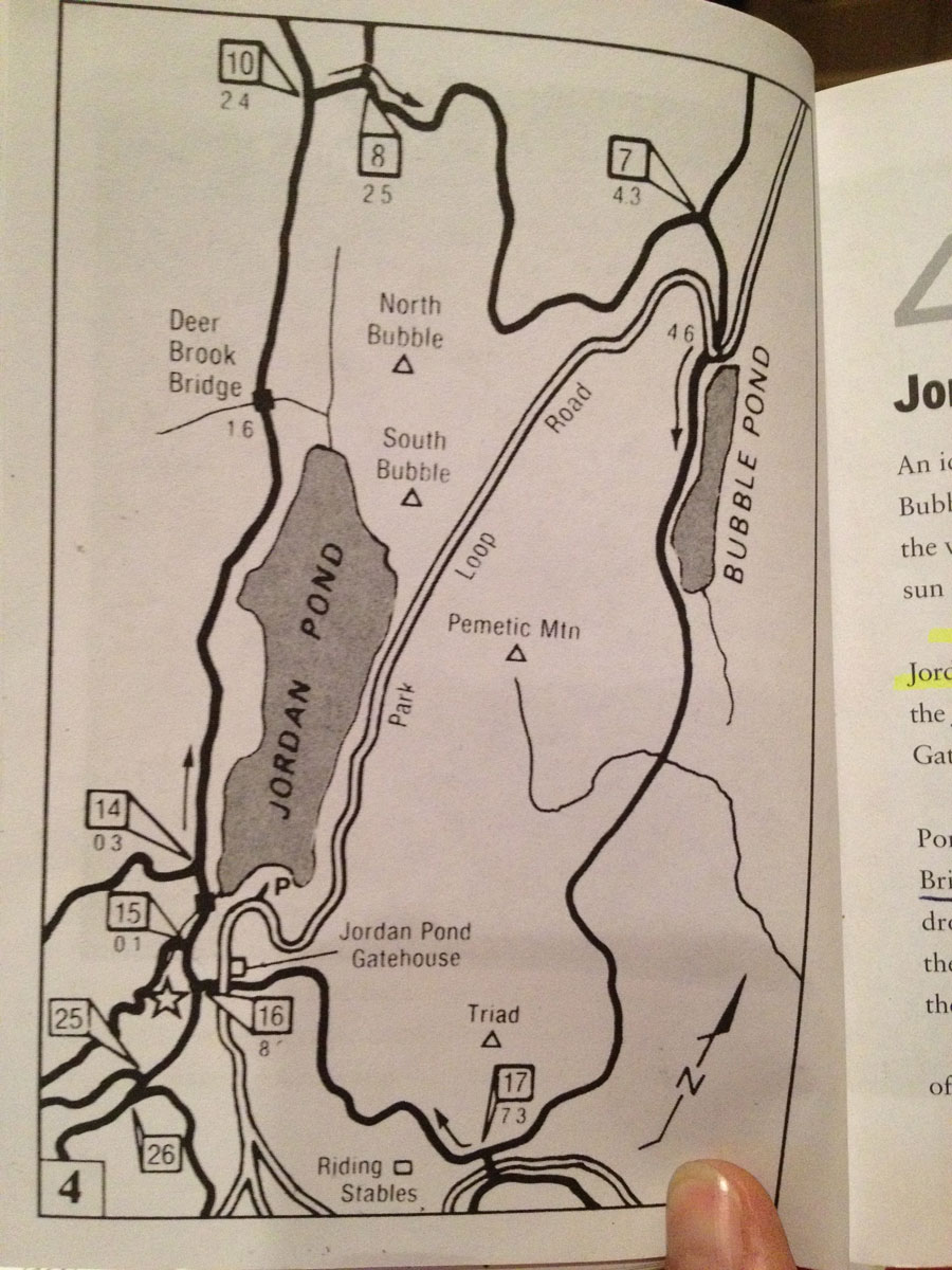
"I started out with my handy dandy little book---A Pocket Guide to The Carriage Roads of Acadia National Park. It's a great little book, it fits nicely in a big fanny pack. It's got a map of each "tour". (Swell, but Sparky can't read maps very well.) Bridges are little black boxes on the map. Here's today's map:


Jordan Pond Gate House
Here are today's directions:
"Park at the Jordan Pond parking lot, .2  mile north of the Jordan Pond Tea House. (Eldy dropped me off, so far, so good.) Walk south, (which way is that? Oh, towards the Jordan Pond Gate House. Thank God they gave me a landmark!) along the Park Loop Road to the Jordan Pond Gate. (across from the Jordan Pond Gate house)  Sparky started out, and rode 1.4 miles. "Starting here, turn right at [16]."

WHOA NELLIE! There's no 16 here, Sparky says...the signpost says 18! Sparky whipped out her little book, read, and re-read the instructions. She THOUGHT the book said, "walk south along the Park Loop Road to the Jordan Pond Gate HOUSE and start here."  So she had ridden 1.4 miles in the WRONG direction, having started on the opposite side of the gate. Back she went, another 1.4 miles all uphill. Back to the gate again. Ask directions from a young man who whipped out a map (never a good strategy to use with Sparky, but he didn't know.) Sparky pretended to understand north, south, etc. etc., smiled sweetly and said thanks. She studiously studied the map (for at least five minutes) to no avail.

Off she went again the other way....This time, directions in the little book jibed with the signposts. "Starting here, turn right at [16].   I did.  "Take a left at [15]."  I did. The downhill run follows the curves of the stream at a fairly steep descent. WHEEE--EEE-E-EEEEEEE!  The little bridges cross the Jordan Stream several times and the scenery was beautiful, once again. Sparky doesn't think there are ANY bad hikes or drives in Acadia, they are ALL beautiful.

Sparky ran into some young Friends of Acadia workers, who volunteer to keep the ditches clear along the carriage roads, who repair culverts and bridges, who do LOTS of things to keep the carriage roads and the park beautiful and well maintained. They were working hard. When asked if she could take a photo of them working, here's what they did, they posed! Sorry, she didn't get their names.

OK, guys, back to work!

"Turn right at [23].  You can on foot, you CAN'T on a bike. The little book failed to mention that a right turn puts you on private carriage roads, and NO BIKES ARE ALLOWED.  Pity the foreign visitors who speak or read very little English. Sparky has heard lots of German and French on the carriage roads. There are little icons with the line crossing through the bike, but they are not posted in the same spot as this sign and it's difficult to tell what road they are telling you NOT to go on. It's probably safe to assume that all private carriage roads are closed to bike riders, at least that's what it seems. That's a very small portion of the carriage roads in the park, and the private roads are in the southern section of the park.

Now what? Sparky went left, UP ANOTHER STEEP HILL to a second intersection. She was going to go around the loop the other way. NOPE! No bikes allowed to the right--another private carriage road. Stiff penalties if you think you could pretend to be a foreign speaking person and shrug, "Je ne parlais anglais." (I don't speak English). Hope that French is correct! Sparky went to the left, riding a loop back to the Jordan Pond House. No awesome bridges today. Just one over a regular road. It's still pretty. Don't ask Sparky the location of this one. She has no clue where she saw it.

But wait a minute....Sparky can call Eldy and say she's not done yet. There's another bridge called the Deer Brook Bridge, and it's nearby! Eldy says, sure! Take all day, ride all afternoon if you want. Yippee! The day won't be a disappointment after all! After getting her park out of the bike rack after getting directions from the ranger how to find the bridge, heheheh...Sparky notices SOMETHING IS WRONG WITH HER BIKE. It appears the brakes have locked up. The back wheel is whining with the brake pads smooshed against the rim. Not good. Sparky can't budge the brakes away from the rim one fraction of an inch. Sparky thinks maybe she overheated the little brake pads breaking all the way down the hills. Maybe they fused themselves to the bike. See? Sparky is a safety conscious rider. Now, Eldo? He rides full blast down the hills, and doesn't use his brakes hardly at all. (Yep, proud to admit, I'm a daredevil on the bike) Yeah, and he will only go on level bike rides and downhill ones....tee hee hee. He's a good sport. He knows I'm teasing.

Sparky calls Eldo...Eldo comes and gets Sparky. They head to the bike shop in Ellsworth...The guy puts the bike up on the rack...he spins the wheel, it locks up, he stops and says, "Hm-m-m-m-m...." The brakes do look a little corroded, he says. He looks a little more, he sees a Krypton coiled up like a snake bike lock locked onto the rear carrier (Sparky had attached the bike lock back there), fiddles a bit with the wheel and says,"There's nothing wrong with your brakes, lady---It's this bike lock coiled up on the back rubbing against the tire." It had moved down into the carrier frame and wedged itself against the tire. He moves the bike lock out of the way of the tire, and VOILA! The noise is gone, the tire spins freely, the brakes are working fine...

Oh........

Sparky sheepishly makes her way to another part of the store to check out kayak supplies....We will say that Cadillac Mountain Sports in Ellsworth, Maine was a great store to shop in and get bike service, even though we didn't need any. They even looked at our Thule bike rack which we are having problems with and tried to help us on that free of charge.  And that was how our day went today...the verdict is still out on whether Sparky is the village idiot or not...Sparky has more stories to tell about herself, but they will have to wait for another day....

Saturday, August 11, 2012

Hiking the Beech Cliff Loop Trail

Bar Harbor, ME     High: 79    Low: 66

Want an EASY hike? Want a short hike? The Beech Cliff Loop Trail is for you! An .8 of a mile "lollipop" trail, a loop returning back to a straight line....forest floor, graded gravel and rock ledges..Piece of cake!  We waited till late in the day today to make up our minds about doing anything, so we needed a short trail to complete in less than an hour. This one fit the bill to a "T".


The wonderful thing about Acadia's hikes, is, you can find anything from the most challenging to the easy....from lengthy, many mile hikes to itty bitty short ones, and every one of them has a scenic view or a payoff for trudging up and down boulder paths, scrambling over rocks, or hey...how about the carriage roads? There you just have to walk up and down steep grades now and then, or bike them if you are in fantastic shape and know how to use your gears....We seem to be lacking in knowledge how to use all our gears, wish there was a class to help with that!

Trailhead location: Head south from Somesville, on ME 102, turn right or west at the flashing yellow light towards Pretty Marsh. Take the second left onto Beech Hill Road at the sign pointing to Beech Mountain and Beech Cliff. Follow Beech Hill Road south for 3.2 miles to the parking lot at its end. The trail for this hike leaves from across the left (east) side of the parking lot.

A couple other more challenging trails intersect off this trail...the Canada Cliff Trail is one.

Within just a matter of a few tenths of climbing up a boulder series of steps, you have the amazing views below.....You are looking down at Echo Lake, and yes, it really was this blue today as we gazed down upon the tiny swimmers below....

A little bit of rock in places, but nothing we couldn't handle
Acadia and St. Sauveur Mountains are off to the east. To the south is Somes Sound, the Gulf of Maine, and the Cranberry Isles. The trail continues along the cliff, then circles inland, closing the loop at .6 of a mile. Another two tenths and we were back at the parking lot. An easy hike with fantastic views today...we highly recommend this one!  Eldy has a more challenging one in mind coming up in the next few days. A ladder trail, maybe?  (HA! says he......)  Short and sweet is never a bad thing, he adds. We'll see where Eldo goes next!

Friday, August 10, 2012

Another Ride for Sparky-The Hadlock Pond Loop

Bar Harbor, ME   High: 78  Low: 62

Eldy has been feeling a little under the weather, so he opted out of a bike ride on the carriage roads of Acadia today. Besides, we had done the Hadley Brook Loop carriage ride two years ago. Sparky wanted to see if she remembered it, and there were THREE bridges she wanted to get photos of, so off she went. Best time to bike the carriage trails is late in the day...You can find parking, and the trails are not as busy this time of day. Sparky has found that around 4:00 PM is a great time to ride. If you go during the mornings or early afternoons, the small parking lots for the carriage roads are completely full, and cars are forced to park along the highway roads for long distances, especially during the months of July and August. Go in the late afternoon, and you can park easily in the designated parking lot. Hiking might be a different story. Not sure you'd want to set out on a challenging hike later in the day. That would best be attempted early in the morning.

She didn't even get out of the campground before calling Eldy, "Uh, honey, which way did you say to turn out of the campground?" Eldo just laughed and patiently told her once again, just like he always does, the man has the patience of Job when it comes to Sparky's inability to use her internal compass and memory banks to get where she needs to go on her own. Eldo knows Sparky needs LOTS of repetition to remember things. And even then, sometimes she forgets, like what appliances are using 12 volt in the motorhome and which ones aren't. But, I digress....

Brown Mountain Gatehouse
You can reach the Hadley Brook/Hadley Pond Loop at a mile north of Northeast Harbor on Route 198. It was about a 15 minute drive from Mount Desert Narrows Campground. The Hadley Brook Loop is a 3.9 mile circuit that rises to an elevation of 500 feet, so that means some SERIOUS hill climbing! Or walking, as the case may be...Sparky was on the bike for some of it, and off for walking the rest of the hill. This hike or ride has a little bit of everything---level spots, steep inclines, a waterfall (well, not in the summer, it's pretty well dried up), and a pond and some really great views except the trees have grown up and obscure much of it. You start out on the carriage road just beyond the Brown Mountain Gate House, one of two gatehouses in Acadia. The two gate lodges were built to control traffic and serve as a gateway entry into the carriage roads. The Jordan Pond Gatehouse was built at the same time as the Brown Mountain one, and they have similar architectural styles. The Brown Mountain Gatehouse has beautiful masonry, spindles in the windows and lots of detail.  There's a lot more to the gatehouse than what you can see in the photo. It extends out both sides and has additional attached buildings. It's beautiful!

If you take this carriage road trail, you get to see the highest waterfall in Acadia when it's flowing (spring time is best) and two of Rockefeller's wonderful bridges--Hemlock Bridge and the Waterfall Bridge. People talk about there being 17 of Rockefeller's bridges, but that number reflects just the ones on the carriage roads. There are more in the park crossing over non-carriage roads as well. You have two choices of how to travel this trail upon starting at the Brown Mountain Gatehouse. You can start uphill immediately, or take a different route for an easier ascent and descent. Sparky missed the easier route in the book and took the high road, which skirts around Upper Hadlock Pond. Not much of a view there, the mature trees now obscure the view. But Sparky took her time, admiring the sunlight dappling through the trees, highlighting the little things in nature that many people just breeze right on by most of their lives. Most people would say this is just an ugly tree stump, but when riding by yesterday, the sunlight on the little crushed pile of leaves made it just glitter, causing Sparky to pause for a moment of reflection. Same for the lichens below....

If you take this trail early in the morning, they say you can hear the loons calling in the Upper Hadlock Pond.

It was a beautiful afternoon to be out riding. Very few mosquitoes, a light breeze and temperatures in the low seventies.

It's not long before you come to the first bridge--Hadlock Bridge. It's modeled after the one in Central Park, NY. This little bridge is a wonderful example of how Rockefeller's vision is captured in the design of this bridge. It blends and harmonizes with nature, drawing very little attention to itself.
Rockefeller and his design team worked very very hard to blend the bridges into the landscape...curving the structures where needed, disturbing the natural environment as little as possible before, during, and after construction, using granite right from the bridge site, and employing a famous landscape architect of the twenties, Beatrix Farrand, to plant native species of plants, trees, and flowers along the carriage roads and at the bridges. When you stand back and look at this bridge, you see how well the granite stone blocks blend in with the boulders and rocks in the stream. Rockefeller even told his granite workers not to cut the stones too perfectly to maintain the rusticity of the bridges. When you come to intersections in the carriage roads, many of them have tree islands with the signs, it almost seems like an invitation to stop and rest awhile.

After passing this bridge, you climb steeply (again!) up the sides of Parkman Mountain to get to the next bridge--the Hemlock Bridge. This is one of the prettiest bridges in the park, in a lot of people's opinion. The bridge has a massive Gothic arch in the center of it. There are two small false arches, one on each side. This was one of the most expensive bridges to build, because they couldn't find enough suitable granite at the site. So they hauled it in from a nearby quarry.
About a tenth of a mile further uphill, (still climbing!) is the Waterfall Bridge. It was constructed a year after the Hemlock Bridge. The Waterfall Bridge is AMAZING!  Unless you are standing underneath it, you can't even imagine how tall it is, and how small you are. The north wall faces a 40 foot waterfall that can best be seen in early spring. Today there was a mere trickle of water coming down the ravine walls and barely enough water in the brook for a melodic tinkling down the rocks as it flowed.
There are two towers that form viewing platforms at the road level. Sparky stopped to admire the work of these early architects and to catch her breath....

From here on out, it was a gradual descent back down to the parking lot. It was a wonderful ride today, and marvelous exercise, too! Until next time.....

Thursday, August 9, 2012

Here, Moosey, Moosey! Some Moose Watching Tips

Bar Harbor, ME    High: 78   Low: 58

Does this mean we saw a moose? Not yet, but we sure know where to look after driving about 11 hours yesterday on the back roads of Maine, some of which shouldn't even be considered roads! We were not sure after we leave here whether we will stay in Maine or head west, so Eldo suggested that we drive over to Greenville for the day, and scout out all the favorite moose sighting locations over there. Sparky said, SURE! And off we went with a picnic lunch on our very own moose hunting safari.

Since this is our second visit to Maine, the first one was two years ago and we DID see moose, we had a good idea of where to go looking again...in the Greenville area near the appropriately named Moosehead Lake. The area is FILLED with bogs, a moose's favorite place to hang out. Moose outnumber people 3 to 1 in the area, so you SHOULD be able to see a moose somewhere either at dawn or at dusk...and maybe in between. Of course, the population numbers of people in this region is not very high as it is a very rugged, swampy, mosquito infested area as well.

When you look at a map of Maine, you don't really see the hundreds of rivers, ponds and lakes that are in the highlands area. It's incredible how much water there is!

We spent hours and hours yesterday driving crazy dirt, stone and gravel lumber roads dodging lumber trucks looking for moose. The weather was cloudy and looked like rain. Do ya think we could find a moose? NOPE! Maybe they weren't out and about today because of that, but it never did rain. The roads we were on were AWFUL!  Here's the route we took, we DON'T recommend it, there are other directions/ways to get to Baxter State Park...(but don't ask Sparky, heh, heh, heh! says E.)

Out of Bangor, Maine, we took highway 6/15 to Greenville. We checked THE spot for seeing moose, but it was too early in the day---the D.O.T. location right off 15, on the west side of the road. We had word from the new visitor center nearby that a mother and her calf frequented the bog.  No moose.

From Greenville, 6/15 splits off to the left. We continued right on the road to the tiny town of Kokadjo. The sign into town says, "Town of Not Very Many." They are not kidding! Just a few buildings, a couple of houses, and a restaurant  compile the little town. Sparky stopped to get a photo of a boulder (little things amuse retirees, don'tcha know?) that she took two years ago. She just liked the setting. It wasn't as pretty a day today, but it still was peaceful.

On to the  Lily Bay State Park area and past it. The road turns into a ROUGH, potholed, gravelly lumber road populated with LOTS of lumber trucks barreling down these roads. GET OUT OF THE WAY OF THE LUMBER TRUCKS! They have the right of way, and they are MOVIN' down the roads, FAST! (Good way to get a chip in your windshield, but thank goodness, we didn't!) We did not go into Lily Bay, but continued on towards Baxter State Park, stopping at every little pullout, every little scenic view of bogs, marshes, and swampy areas looking for moose. Sparky saw a muddy bridge crossing, with---COULD IT BE!!?? MOOSE FOOTPRINTS!  There MUST be some moose nearby!  These looked fresh! ON WITH THE SEARCH!


It's a beautiful drive, although the roads are crappy...you are passing through the Penobscot River Corridor, and there are boondocking campgrounds along the way, (a big rig could get in, but who'd want to drive along these roads to get there unless you come from the OTHER direction) and some awesome rapids to see....about a class II in the areas we looked at.

Sparky experimented a little with her camera settings to try and get the flow of the water....Not bad...

It was getting late in the day...but still no moose sightings....We stopped at a small campground called Abol Bridge Campground...The views of the nearby mountains were breathtaking.

The campground was boondocking only, as are quite a few campgrounds in the area. Eldy talked to a gentleman who was asking about our Honda CR-V. The man had just had a fire in the CR-V while pulling it down the road, and the car was totaled along with damage to his rig. He said a blowout was the cause, but since he didn't have a tire pressure monitoring system, he didn't know it until it was too late. Insurance covered his loss, fortunately.

We enjoyed talking to him, he's been a full timer for eleven years!...He gave us another spot to check for moose about three miles down the road...It was the PERFECT, shallow bog, HUGE grassy area...But, NO MOOSE!  With that, on we went, we looked a little more and found another spot.....No moose, just a beautiful view...sigh!
Time to head home, Sparky! It looks like we are not going to see any today, but we'll go back again....We'll leave you with some moose facts and a few top locations to look for moose in the Maine Highlands area:

1. The flap of skin under the moose's throat is called a bell.
2. Moose have no top front teeth.
3.After the first calf, moose frequently have twins.
4. Only the males grow antlers, and they shed them in early winter and start growing them again.

Best times to see moose:
1. Early in the morning, and at dusk
2. Best time of the year is May and June.
3. Moose prefer shady, wet areas such as bogs and marshes.
4. Driving after dark is a common time to see them--be careful! The lady at the visitor center in Greenville said three moose had been killed on highway 15 this summer in the Greenville area.

Moose hangouts in the Highlands of Maine:
Note: Not being from the area, some of the places on the list might be the same names or spots repeated. These moose hunting locations are taken from more than one source of handouts the visitor center gave us and a couple of them seemed to be talking about slightly different areas.

1. the D.O.T. (Department of Transportation) heading north towards Greenville, as you drive thru Shirley, watch for it on the left, across the road--the Shirley Bog
2.Kokadjo--stay on Lily Bay Road for twenty miles, watch for moose
3. Lazy Tom Bog--continue 1.5 miles past the bridge in Kokadjo. Stay to your left, then take the intersection to the left and continue half a mile more to the bridge over Lazy Tom Stream.
4. Mount Kineo/Rockwood--Drive to the town of Rockwood, (north of Greenville), head to Mt. Kineo for hiking or exploring, watch for moose. Route 15 is Rockwood Road in this area (?)
5. 20 Mile Road
6. the Golden Road
7.  Sias (?) Hill Gate of the Golden Road
8. Lily Bay Road

And if you don't find any moose, hire an outfitter! There are more than 17 on the list we were given. We did that two years ago, went early, EARLY in the morning on a kayak adventure to see moose, and didn't see any! So no guarantees, folks, the fun is in the hunt. We really enjoyed ourselves today even if we didn't see any moose, and that's all that matters!  Bye for now.....

Wednesday, August 8, 2012

Driving Acadia Park Loop Road Part II

Yesterday, we left you at the Fabbri Memorial and picnic area, once the site of a naval radio station. This is a great area to stop and eat lunch, with flush toilets and decent restrooms to freshen up after lunch, not your usual pit toilet area. We didn't take photos here, but the picnic tables are in great condition, they are almost all in shaded areas surrounding by lush vegetation, and we really didn't have a problem with bugs or flies while we stopped and ate.  On to the Otter Cove Causeway Bridge....


Hard to get a good photo of this one with the sun angle late in the day...constructed in 1928, the bridge is made mostly of solid rock fill. Despite the name, sea otter do not live on the Atlantic Coast so you won't see any at Acadia. We continued on our lovely drive, passing the Wildwood Stables, home to the fabulous carriage rides on the carriage roads....(see the previous post about our bridge tour)

Next stop....Jordan Pond House....a favorite destination since the 1800's, but reconstructed in 1979 after a fire. However, the popovers on the lawn are a vintage tradition still continued today. You have to make reservations ahead of time to eat there or have a popover, it's so busy!

There are several trails out back behind the house, a walk out back leads you to Jordan Pond in the background with fantastic views of Penobscot Mountain, the Bubble Mountains (in front) and Pemetic Mountain. Come back out front, and across the street is a gatehouse and tower entrance to the carriage roads built in 1932 and residence for park workers today. It is absolutely gorgeous!

This is the side of the house...the architectural details are wonderful....This is one of two gatehouses in Acadia. We have not seen the other one yet.
After leaving Jordan Pond House, we saw the famous rock called Bubble Rock. It's really a large boulder, weighing somewhere between 11 and 14 tons. It looks like it's going to fall any second, but it's  actually very stable. Another name for this boulder which looks like it's been placed into a position where it doesn't belong, is a glacial erratic. You can hike a trail to Bubble Rock if you want. It looks much more impressive close up!
Next, a mile or two down the road is Bubble Pond, one of the prettiest ponds in the park. It looks more like a lake. You are NOT allowed to swim or wade in Bubble Pond, Eagle Lake or Jordan Pond, as they provide water for neighboring towns. There is a 6.1 mile carriage road that goes all around the lake.

You pull into the parking lot and see a wonderful bridge there, the Bubble Pond Bridge. It's one of the 16 carriage road bridges John D. Rockefeller, Jr. built. The area around this particular bridge has spectacular scenery and has a peaceful and reflective atmosphere. John D. struck a delicate balance between preserving nature and providing access. At the time of the construction of the carriage bridges and roads, Rockefeller knew he wouldn't be able to keep the automobile out of his beloved woods, so he envisioned a system of carriage roads and bridges that would give access to future generations for many years to come. He was a remarkable man way ahead of his time with his vision. More about the carriage roads and the bridges in another blog. Back to the tour!

Bubble Pond Bridge
At this location, you can take a strenuous hike up the steep west face of Cadillac Mountain if you wanted to. We didn't.....But Sparky might another day! (I was afraid that was coming, says Eldo.)

The next to the last stop is Eagle Lake...Here is where Sparky started her bike ride the other day, and she posted a photo of the Eagle Lake bridge. It's a beauty, too....So here it is again.....

Sparky's goal is to see all 16 of Rockefeller's bridges in the park before she leaves. The 17th one was built by the park service and crosses Park Loop Road...Many of the bridges are in the heart of the park and you have to hike or bike to get there. We have two weeks remaining, it should be an attainable goal as we've seen at least five so far.

The last stop on the Park Loop Road is following the road to Cadillac Mountain. We had already done that, so our tour for the day has ended...It was beautiful weather, the sights were wonderful, and we've gotten to know the park more intimately. We highly recommend purchasing the little book, or you can get the audio tour for the Park Loop Road at the visitor center. The longer we stay here, the more we love it and know we will be back.