Sparky decided on a moderate hike called Pennys Preserve via Peter's Brook Trail, a 2.8 mile hike and not too far from Patten Pond RV Park where we are staying. It's fifteen miles and a 23 minute drive near Blue Hill, Maine. Hike through a forest, view a waterfall and some old granite quarries. Dogs are permitted to run loose after entering the preserve, which is VERY unusual for most public trails, but this is a privately owned parcel of land, so they allow that.
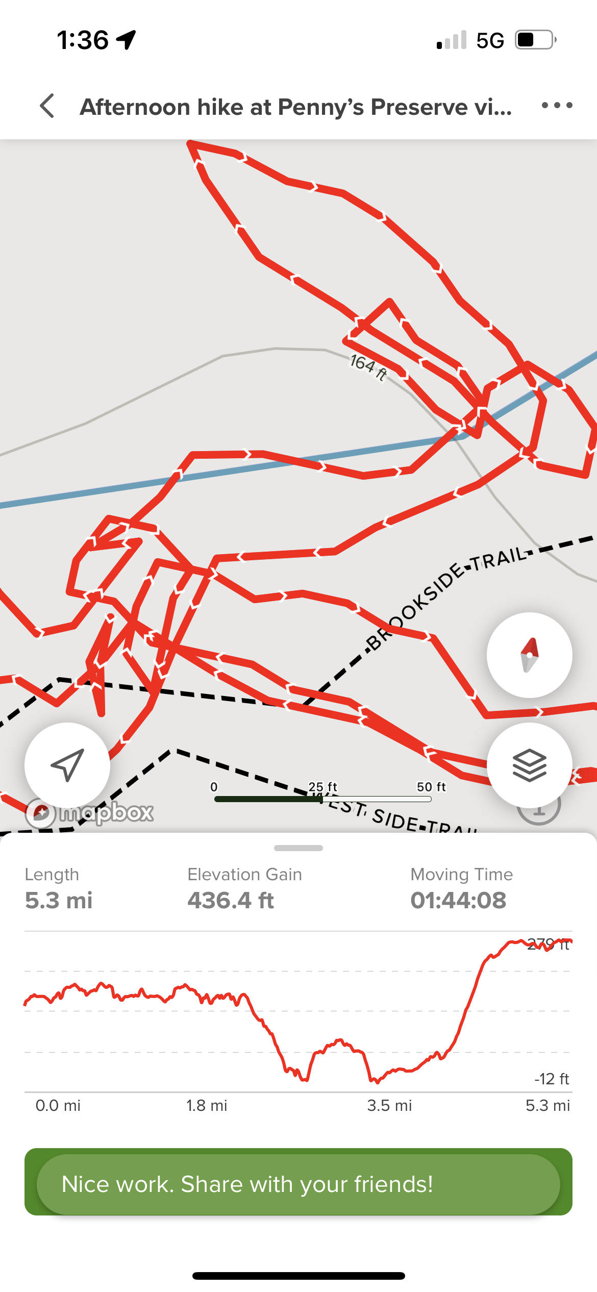
Bug repellent? Check. Hat? Check. Water? Check. Check in with Eldy upon arrival? Check. Phone and the All Trails Map app that will track you while you hike? CHECK. (Key detail here.) So-o-o-o-o...Sparky has not used this app much because she hasn't needed to. But after starting the hike and finding the blue blazes painted on the trees to be sparse and not very prevalent, she decided to whip out the app and start tracking. The trail is red and it looks like this on the map: You click the navigate button on the app, and a little arrow starts tracking you as you move, making ANOTHER red line the same as the trail line. (key detail). Sparky is hiking along, and after about 1.75 miles, realizes that #1. She picked the wrong trailhead parking lot (which was only a two vehicle space lot which might present problems later getting out) and #2- the trail she was on, Pennys Preserve, was not going to take her past the "3 bridges and a waterfall" listing that was on the OTHER trail, called Peter's Brook Trail, that intersected into this one. Or maybe she had it backwards. Maybe she was on the Peters Brook Trail and she was going to miss the cool stuff on the Penny's Preserve Trail. Whatever....She's simply going to back up her little ole self making the arrow on the map retrace her path and take her back to the parking lot where she will go find the OTHER trailhead parking lot and see the bridges and waterfall. She's not sure what happened next. The trails are poorly marked. No clues that the trails will loop back to either parking lot. The arrow on the map turns when you turn and marks a little red squiggle when you demonstrate confusion as you twist and turn, trying to figure out which way is where. There were several signs with a map that said, "You are HERE."

But Sparky wanted to be THERE and unsure of herself, and logic failing that these were LOOP trails, and that she would eventually return to the parking lot, escaped her for the moment. What compounded her panic was there was NOBODY on the trail for a very long time. She kept looking at her navigational arrow on her trail map and after awhile, it looked like this: Seriously.... All those little dots between the dashes are temporary stops. Finally, she found herself at the waterfall with no idea how she got there, and she saw PEOPLE! Woo hoo! She asked the group how to get back to the parking lot, and they said, "Oh, just go up that trail up there, (pointing in a vague direction). Sparky had already been on that trail TWICE and from the map it looked like she would be repeating the same smaller loop again. By this time, she was a little panicky. She knew in her mind that if she kept on the loop trail she would eventually get back to the parking lot, but she was just panicked that it would be a repeating loop and she wouldn't exit it in the right place. So she decided to just set off. A few minutes later, along came a couple, with their beagle out for a Sunday stroll, and she told them she was lost and could they direct her towards the parking lot? They said sure, just hang out with us. They said they had parked at the Peter's Brook Trailhead which was the opposite of Sparky's truck position, but she didn't care. It was company, and off we went. They were really nice company, and their dog very sweet.


Since that hike was just a teeny bit stressful, Sparky had to take advantage of some free ice cream at the ice cream social at the park that day. Whew!

Because we are leaving the area, and heading back to Wells, Maine, and mainely (haha) the beach, Sparky went out for one last hurrah bike ride on the carriage roads in Acadia. Gosh, those roads are tough--lots of climbing, but it helps if you check your tire inflations before heading out. Just sayin'.....Sixteen miles was enough for today...

And heading towards mid July, the waterfalls and brooks are drying up! As always, check out the bridges along the carriage roads, especially the undersides. There are trails leading down below, but they are usually rocky and a little on the precarious side for an older person. But to view the bridge from underneath is wonderful. You can really see the architectural details that way.
 |
| West Branch Bridge Jordan Stream |

The iconic Eagle Lake Bridge is a very popular starting point for riding the carriage roads. Very small parking lot, Sparky suggests starting elsewhere....

The blueberries are starting to bloom along many of the trails in the area.

Glad it turned out well. Thank goodness for other hikers at just the right time.
ReplyDeleteFor sure! I'm sure I would have made it back to the parking lot eventually, but the thought of walking around the loop AGAIN was wearing me out from even wanting to try.
ReplyDeleteIf that's what you did today then we were both lost together in different places. First I took the wrong trailhead and had to come back. Then I took a wrong turn and had to turn around. But like you would all turned out well. Three weeks at the beach sounds fabulous.
ReplyDeleteI'm getting very tired of blogger forgetting who I am and labeling my comment as anonymous. This time it wouldn't even give me the choice for my Google account. Anyway, this is Sherry
DeleteGuess we're just faceless people in a very big world to Google! thanks for identifying yourself! This is Jeannie lol.
ReplyDelete